Did hail hit? Check any address & get text alerts to your phone.
Enter an address or ZIP and see every hail day on record nearby — the date, the stone size, and how close it landed. Free, no signup. Then turn on free SMS storm alerts: homeowners get told the moment hail hits their roof, and contractors hear about every storm in their market before the door-knocking rush starts.
Hail Tracker
Free lookup — NOAA radar + NWS storm reports
Data: NOAA radar-estimated hail (address-level, ±0.25") + National Weather Service storm reports, hail ≥0.75". Radar coverage back to mid-2023.
Three steps from “did we get hit?” to first on the block
Look up any address
NOAA radar-confirmed hail at the exact address plus verified reports nearby, going back three years. Date, size, distance — no map to squint at, no login.
Turn on storm alerts
Homeowner or contractor — register your number and the area you care about. When hail lands, you get a text the next morning with size and location.
Text STORM anytime
Driving past a neighborhood that looks hit? Text STORM and get the latest hail activity for your area on the spot.
Work your area on the live hail map
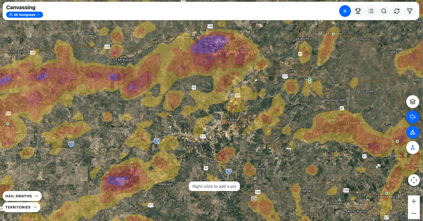
- Your whole state at street level, three years of storms already on it
- Three years of hail swaths, filterable by stone size
- GPS door-knocking, pins, jobs and estimates — the full loop, not a preview
- Month-to-month, cancel anytime
One state, one user, everything included. $79/mo, cancel anytime.
Running a crew? See the whole CRM in a 15-minute demo
Still comparing? HailMate, HailTrace, Hail Recon, HailStrike and RadarScope side by side — every price from the vendor's own site.
Did hail hit your address?
The lookup at the top of this page is the whole thing — every hail day on record for your address, the date and the stone size for each one, and the full report emailed to you to keep.
Check my addressFree, and no account needed to look it up. If hail did hit, you'll have the date and the stone size in writing — which is the first thing an adjuster asks for.
Now that you know a storm hit it
Three free tools that measure the roof itself from the same address — no tape measure, no ladder, no signup.
Put this tracker on your own site — free
Give your visitors the same address lookup, styled to sit cleanly on any page. Homeowners check their address on your site instead of a competitor’s. It takes about two minutes, and you don’t have to be technical — there’s a button that emails the whole thing to whoever built your site.
Copy the code
<script src="https://hailmate.ai/hail-tracker.js" async></script>
<a href="https://hailmate.ai" data-hailmate-badge>Hail tracker by HailMate</a>
You do not need to understand it or change anything in it. Copy all of it.
Paste it on your website
What is your website built with?
- 1Open the page you want the tool on and click Edit.
- 2Click the + button where you want the tool to sit.
- 3Search for Custom HTML and choose it.
- 4Paste into the box, then click Update.
It can take a few minutes to appear after you publish.
It carries a small “Powered by HailMate” badge — that’s the whole price. How the widget works
The tracker tells you a storm happened. HailMate tells you which doors to knock.
Inside the app, NOAA-verified swaths land street by street on your canvassing map — layered with your pins, claims, photos, and crew activity. Storm data tied to your operation, not just the weather.
Was there hail at my house? How to check any address
A hail damage lookup by address is the fastest way to know whether a storm actually reached your roof. Enter a street address or ZIP code in the hail tracker above and you get the hail storm history for that exact location over the last three years — the date of every hail day, the maximum stone size, and how far away the nearest verified report landed. It covers the continental US, it's free, and the report takes seconds.
Most “hail reports near me” searches end at a county-level news story or a paywalled hail damage map. This storm damage lookup goes a level deeper: NOAA radar measures hail at the individual address, and verified ground reports confirm what people actually measured on the ground nearby. Together they answer the question a news headline can't — did hail hit this roof, and how big was it?
What size hail damages a roof?
Under ¾" — pea to dime
Rarely damages a roof in good condition. Older shingles can lose granules, which shortens their remaining life without leaving obvious marks.
¾"–1" — penny to quarter
The threshold where damage starts. Expect granule loss, dented gutters and soft metal, and bruising on aging or brittle shingles. Worth an inspection.
1"–1½" — quarter to ping pong ball
The insurance-claim zone. Quarter-size and larger hail bruises and cracks asphalt shingles, dents vents and flashing, and typically justifies a roof inspection on every home in the swath.
1¾" and up — golf ball or larger
Severe damage on nearly every roof it touches: cracked and punctured shingles, broken skylights, split siding. Storms this size drive full-neighborhood replacements.
Roof age, slope, and material all shift these thresholds — a 15-year-old asphalt roof can be totaled by hail a brand-new metal roof shrugs off. That's why the lookup reports exact sizes instead of a yes/no verdict.
Radar-detected vs. reported hail — why the lookup checks both
Ground reports are the classic source for a hail damage check: a trained observer measured a stone and called it in. They're reliable but sparse — hail that falls at 2 a.m., over farmland, or in a neighborhood where nobody reports it never makes the record. NOAA's national radar network closes that gap by estimating hail size continuously across the country, address by address, accurate to roughly a quarter inch.
When you run a storm damage lookup here, radar-confirmed hail at the exact address is marked separately from reports nearby, so you can tell “a storm passed through the area” apart from “hail landed on this roof.” For contractors, the unreported radar hits are the interesting ones — those are the streets no competitor knows about yet.
Recent hail storms by city
Working a specific market? We keep city-level hail maps with storm history, hail seasons, and the benchmark storms that shaped each metro: Dallas–Fort Worth, Austin, San Antonio, Denver, and Oklahoma City — or browse all hail maps by city.
The lookup found hail at your address — now what?
For homeowners: save the storm dates and hail sizes from your report, then get a roof inspection before filing anything — most insurers give you roughly a year from the storm date to claim, and an inspection tells you whether there's a claim worth filing at all. Hail bruising is hard to spot from the ground, so recent storm dates matter more than what you can see from the driveway. Register above as a homeowner and we'll text you the moment future hail is detected at your address.
For roofing contractors: register above and every future storm in your market becomes a text message with the date, size, and location — before the door-knocking rush. When you're ready to work the swath street by street, that's what the hail maps inside HailMate are for.
Frequently asked questions
Evidence Grade™ — HailMate’s three-source hail verification. The radar-estimated hail size (the same data premium hail-map tools resell) tells us whether hail hit your exact address — accurate to about a quarter inch, with history back to mid-2023. Verified ground reports add human confirmation nearby: when you see "1.75in, 3 miles away," someone actually measured that stone. We show hail of 0.75 inches and up, the size range where roof damage starts.